 Smapping. That's what Mike Sowden calls it when you become your own cartographer/photographer:
"Smapping is the process of taking a digital photograph of a map that you won’t have access to later, except if you take a snap of it."
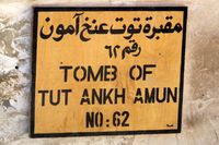
This is brilliant. I've done something similar by snapping signs and information boards when I didn't want to copy down a lot of facts. Just photo it, and it's yours for posterity. It's like having a researcher/assistant on board taking notes.
But I didn't really think about it for local maps. That is, to have one on your camera, instantly.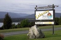
Using a photo of a map in real time may not be as nice as having an actual map of a place. But if you don't have one, I could see where a photo could come in very handy. As Sowden points out, it may seem small, but you can zoom in for details.
I like taking photos of local historical or informational signs because they're often more detailed than explanations in guidebooks. Or contain facts that you might not see anywhere else.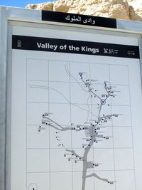
Another reason I snap is to place the scenery that I'm photographing once I get home. Sometimes, the places all begin to merge in my mind days or weeks later. If I take photos of signs as I enter or leave a place, I will know where my photos are from.
 Photos: Ellen Perlman
1- Valley of the Kings, Egypt
2- Manapouri, New Zealand
3- Skylab sign in Houston Space Center Museum

Leave a reply to Dominique Cancel reply